Integrating Sediment Dynamics into Flood Risk Modeling in Koshi River Basin

In many hydrological workflows, reliable sediment observations are sparse or uneven. This project tests whether satellite imagery can estimate SSC well enough to support more robust flood-risk modeling.

Presented at ASPRS Mid-South Region Conference 2026.

Project Context

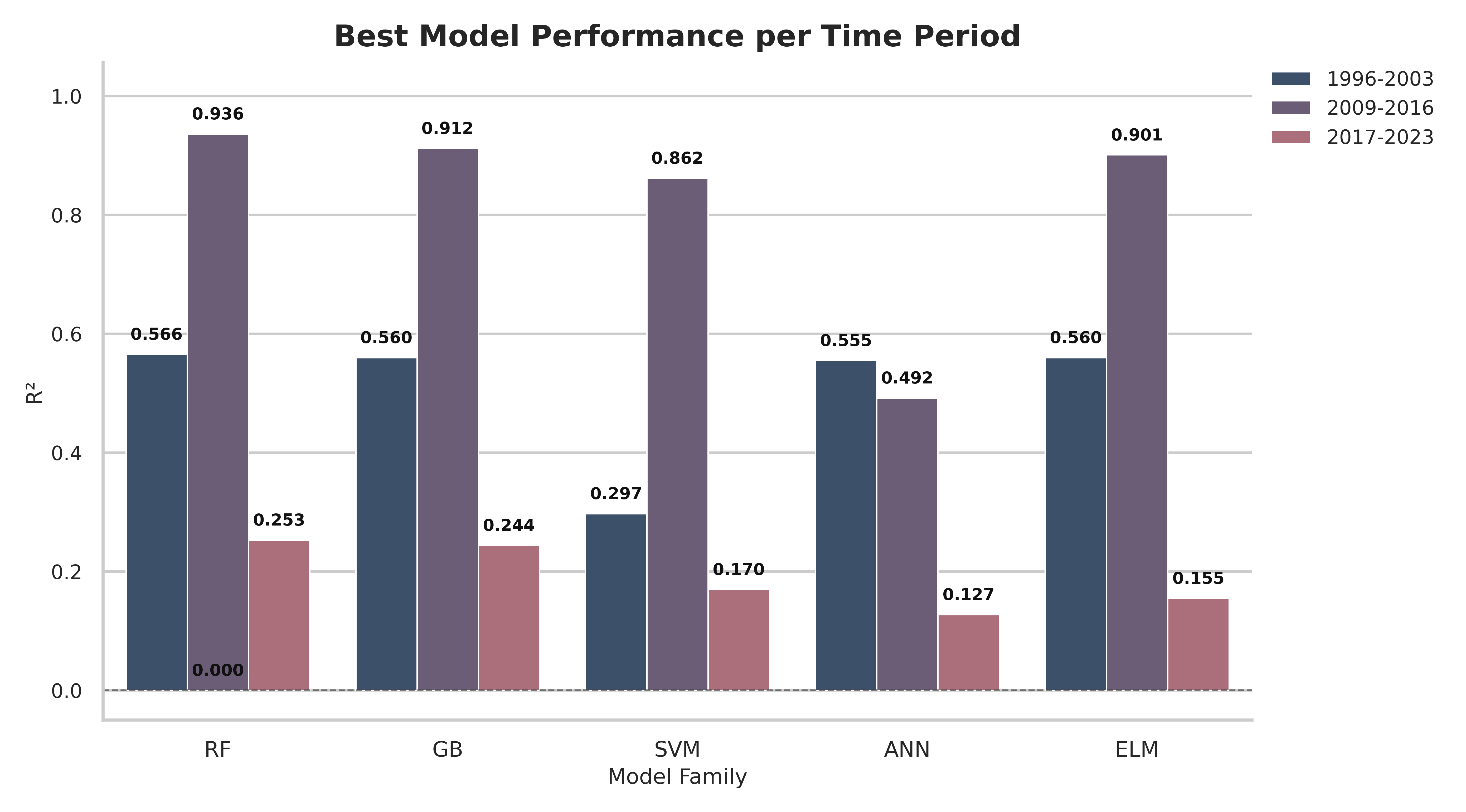
The Koshi River Basin is one of the most flood-prone regions in Nepal and northern India, with recurring flood events that cause major social and economic losses [1]. Existing flood-risk literature and workflows often emphasize static predictors such as elevation, slope, and drainage, but they do not consistently account for one critical dynamic factor in Koshi: sediment behavior [2]. This project was designed to complement those methods by testing whether satellite-only spectral information can estimate SSC reliably enough to support more robust flood-risk modeling.

Key Constraints

Information & Methodology

Data Source

In-situ SSC observations were provided by the Department of Hydrology and Meteorology (DHM), Nepal. Satellite imagery was retrieved through Google Earth Engine using Landsat 5, Landsat 7, Landsat 8, Landsat 9, and Sentinel-2 collections.

Data Inputs

The SSC estimation workflow uses multispectral surface-reflectance bands from Landsat and Sentinel imagery: Blue, Green, Red, NIR, SWIR1, and SWIR2. These bands are chosen because suspended sediment alters visible/NIR reflectance patterns in water.

Sensor Harmonization + Feature Space

Landsat and Sentinel have different native characteristics and spatial resolution, so scenes are harmonized/resampled before modeling. We then build spectral feature sets (raw bands + engineered transforms) and compare model families across time periods.

Aggregation and Mapping Logic

In-situ SSC dates are paired with nearby satellite overpasses using a constrained lag window. For mapping, NDWI-first masking is used to isolate water-focused pixels before spatial SSC prediction.

Results

Best Model Performance by Time Period

The strongest model behavior appears in 2009-2016, while transfer to other periods is weaker. This indicates period-sensitive learning behavior and supports using cross-period diagnostics instead of relying on one best-case score.

Best model performance per time period
Model-family comparison across time periods.
Spatial SSC figure 1
Spatial expansion check #1: NDWI-based masking identifies likely water pixels, then SSC is predicted spatially within that mask.
Spatial SSC figure 2
Spatial expansion check #2: repeating the same workflow on another case verifies that predicted high-SSC zones remain physically plausible along active channel areas.

Why Spatial Expansion Helps

Point-based SSC values are useful for calibration, but they do not show spatial sediment structure. Expanding to NDWI-masked spatial prediction helps reveal where sediment concentration is likely elevated across the river corridor, which is more informative for flood-risk interpretation.

Next Steps

Address data scarcity by filling temporal and seasonal gaps with additional usable scenes, improve atmospheric correction robustness, and explore SAR-supported alternatives for cloud-heavy periods. The next phase focuses on improving cross-period transfer stability with better gap-filled training coverage.

References

  1. ADB: Emergency Flood Damage Rehabilitation Project, Apr. 2009, www.adb.org/sites/default/files/project-documents/43001-nep-rrp_0.pdf. Accessed 15 Mar. 2025.
  2. Sinha, Rajiv, et al. “Basin-Scale Hydrology and Sediment Dynamics of the Kosi River in the Himalayan Foreland.” Journal of Hydrology, vol. 570, Mar. 2019, pp. 156–166, doi:10.1016/j.jhydrol.2018.12.051.
  3. Stull, Trevor, and Habib Ahmari. “Estimation of Suspended Sediment Concentration along the Lower Brazos River Using Satellite Imagery and Machine Learning.” Remote Sensing, vol. 16, no. 10, 13 May 2024, p. 1727, doi:10.3390/rs16101727.
  4. ICIMOD: “Sediment Management in the Koshi Basin.” Sediment Management in the Koshi Basin, ICIMOD, Dec. 2021, www.icimod.org/wp-content/uploads/2021/12/1200g_20211202_PB_SedimentManagementInTheKoshiBasin_AF.pdf. Accessed 15 Mar. 2025.

Acknowledgements

This work was supported by the Drapeau Center for Undergraduate Research (DCUR), University of Southern Mississippi (USM).

The authors acknowledge HPC at The University of Southern Mississippi supported by the National Science Foundation under the Major Research Instrumentation (MRI) program via Grant #ACI 1626217.